
mount whitney was amazing! upon returning from new york, i had a 36 hour turn-around before leaving for mount whitney... it was ridiculous considering i still had to pick up rented gear, go to a work meeting, go to work, sleep, and pack all before leaving again... (pity party, please... thanks) so for those of you who may not know, mount whitney is the tallest peak in the continental united states. second tallest peak in america... it tops out at 14,492 feet. it's located in southern california, ironically, right next to the lowest point in america, death valley (-280 ft). it is the farther away peak that's taller than the 2 poinky peaks in the center. it's hard to see, but our route went up the small (very steep) snow field on the right side of whitney. then it went slightly behind the peak out of view of this shot, where we had a class-3 scramble (relatively exposed and needing to use hands to get up rocks) followed by an even more relatively exposed (i'm using delicate words here, mom and dad, so as not to frighten you) and slightly steeper snow field. i will try to give you a play-by-play in my hike... all in all, it was SO amazing. very physically demanding (even for me... wow).
sunday night-get home from new york
monday-work meeting. nap. laundry. nap. lay things out for packing. work night shift.
 tuesday-get off work. pick up rented tent. pick up rented mountaineering boots. pack. sleep for 2 hours. transfer stuff into genevieve's car half asleep. leave for mount whitney. sleep 3 more hours in car. dinner in ely. change drivers (me). get lost in ely. find our way in ely. get pulled over between tonopah and bishop (i set cruise control at 82. speed limit 70. cop comes up to the window and says he clocked me going 79. he asked, "is there a reason you were going so fast?" -pause, think- "no." gave him my license and gen's registration. he comes back a few minutes later, "i'm going to give you a warning." -"i'll slow down.") i slow down to 75. drive to lone pine california. stay in hotel. this picture is how i pack... lay everything out so i can see how it has to fit in...
 wednesday-wake up refreshed. go to breakfast. start driving to trailhead. turn around in drive to trailhead because boys locked keys in their car. this picture is boy trying to break into the locked car... luckily, gen had aaa... they were there within 60 minutes... so we got to the trailhead about 2 hours after originally planned because of this little fiasco...
 getting to the trailhead was another fiasco... the road leading to the trailhead was closed because they were blasting rock (yeah, it didn't make much sense to me either). so we hiked straight down a ravine and straight up the other side to a trail 3 miles long leading to the actual trail... it was all very complex. here are some photos of the first day...


me and gen at the start before going down the steep ravine. this is a stream crossing at the bottom of the ravine. there were rocks to step on, and this lovely log to use for balance, but things are much more difficult with 50 lbs packs on.

 this is the actual trailhead and the whole crew of us that went on the mountain. and some of the beautiful scenery.
  also, another stream crossing made difficult by the pack weight...
  also, scrambling up rocks we could normally hop up is very difficult with heavy packs. in this particular maneuver, i had great hand holds and great foot holds but nothing inbetween, so i reached as high as i could, jumped, held onto the rock, belly-flopped myself onto the rock and sorta swam up the rock until i could put my knee on the higher ledge and stand up. our elbows, knees, and shins are currently very banged up. gen had an unfortunate boob-smashing incident while attempting this maneuver as well... moral: backpacking is hard. we camped at lower boyscout lake. it was only fairly windy and not as cold (only about 10-20 degrees at night) as it would have been had we camped higher. lower boyscout lake is 10,300 ft high.
thursday- wake up sore. talk amongst campers our plans for the day. we have 2 choices: 1-we can leave this as base camp, pack lunches, crampons and extra clothes and make a long hard push for the summit today and return to base camp. or 2-we can pack up base camp, hike straight up 2 miles to iceberg lake with our 50 lbs packs, and have an easy summit day tomorrow then hike out either tomorrow or saturday after summitting. we decided to make a hard push for the summit. we threw in our headlamps, extra warm clothes, sunscreen, lunches, lots of snacks and headed up for the summit. as i said, lower boyscout is 10,300 ft. we had to gain 4,192 ft in elevation over almost 3 miles... if that gives you an idea of steepness... 

in this photo: there is a small lake down there situated between the base of the mountain and the snow field, in front of the clump of trees. that is lower boyscout where we set up base camp.

in this photo, the frozen lake in the back-ground is upper boyscout lake. this is 11,300 ft. 

we thought this was steep... the photo doesn't do it justice. look at the climber's left foot. turn the picture so his foot is parallel to the ground... that gives a more accurate view of the grade of this stretch of the climb... still not the steepest, nor the longest, by far. this is just past iceberg lake (12,600 ft). by the way- we had crampons on all day. it's like chains on your tires or 4wd, but for feet. amazing the traction they give...

the peak on the left of this one is mount whitney. if you look at the snowfield going up the right that disappears behind the peak... that is called a couloir. that was our route. again, the photo doesn't really do it justice for steepness, but as you can see, it wasn't flat, by any means. 

this is at the start of the couloir. gen and jason coming up. 

because we got started so late, the couloir was mostly in the shade. this was one of the few sunny spots we found to rest. 

fortunately, and unfortunately, the altitude didn't effect me too badly, so when waiting for others to catch up, i froze. this is me, trying to stay warm. thanks, ned, for my wonderful shirt... it goes with me everywhere! and, i might add, looks amazing when pulled over my helmet. 

part of the relatively exposed class-3 scramble... 

looking up at the even more relatively exposed, steepest part of our climb. the last snowfield. it was about 40-50 yards long. i slipped here on the way down, but i had my ice axe driven in, so when my feet kept going, my axe stopped me... but that wasn't what scared me! the worst part of the trip was hiking out on friday, we had to hike out on the snowfields we had come up on with 50 lbs packs! but back to thursday...
this is the last snowfield. the steepest part of our climb. about 150 ft left to go!

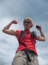
me on top... apparantly, i own a lot of green things... 

view of the sierra range from the top. it was breathtaking. (not a pun to intend the lack of oxygen at 14,492 ft)... we were at the summit by 4:00 in the afternoon. it had taken us 8 hours to summit from base camp. we still had to hike down. we stayed at the top long enough to snap a few photos, steal my summit rock, and off we were. we wanted to be out of the couloir before dark. we were. we threw on our head lamps about half a mile below the couloir and hiked back to base camp with our headlamps on. we were eating dinner by 9:30 in our tents. we had a mostly full moon, but it didn't rise until 10 or 11, so that was of no use to us. the stars were plentiful and the air was clear and crisp so we could actually see them. lone pine is too small of a city to let light pollute the night sky. statistics show that only 33% of those who attempt mount whitney actually summit. of the 6 of us attempting, 5 made it to the top.
friday- sleep in. wake up sore. eat breakfast late. gen and i's breakfast: mountain home raspberry crumble (actually a dessert), hot chocoloate, trail mix, chicken broth, gatorade. we were very dehydrated from the previous day's activities, and apparantly, very sugar-deprived. pack up camp. hike out. did i mention that we had to pack out our poop? crapbags are fun... 

our breakfast... mmmm!!

base camp. right next to a babbling brook. we filtered our water. look across the lake at the snow... that was our route yesterday.

a zoomed-in version of our route yesterday. pretty much, we went straight up the snow in the middle, around the rock peak in the center of the picture, over to the couloir which you can't see, then straight up to whitney which you can see just the tip of here. this was our view from base camp... looking back on what we did... it's amazing what your mind can tell your body to do when you want something bad enough!

scrambling down the ebersbacher ledges... which is very difficult to do with packs on. jason went down first then would spot me as i came down.

sean-paul helping gen down. again, easy hop up and down, but with packs, everything is difficult. 

off the mountaineer's route and back onto the whitney portal trail. 

one last picture. same as first picture... but now you appreciate it a bit more, don't you? we hitched a ride from the whitney trailhead back to our car, seeing as how the road to the trail head had opened on thursday. that saved us another 6 miles of walking on the road, or going back down the miserable scree in the ravine. i will definitely hike this mountain again. i would like to do it in one day though, just to say i can. but to sum up from the actual trailhead we gained 6,200 ft in 4.7 miles. from our car to the trailhead, i'm guessing we gained 2000 ft in 2-3 miles, which isn't as steep, but we had to go down one steep ravine and up to the other side, so it was a dramatic fall and rise in elevation from the get-go.
from base camp, i could see the peak and think "man! that's a long way up. that's straight up. we've got a long way to go." then after summitting, and getting back to base camp, i looked up at the peak and thought "man! that was a long way up, but HA! take that! silly mountain... 14,492 feet. pshaw. i could do that in my sleep."
1 comment:
You know what they say about girls who hike big mountains...yeah, I don't know either.
Post a Comment